Satellite companies restrict journalists’ access to images from the Iran War
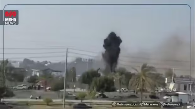
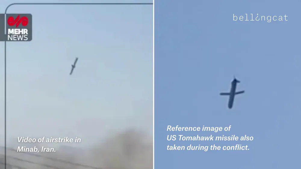
In the days after a missile slammed into a girls elementary school in Minab, Iran on Feb. 28 killing about 175 people, most of them children, open source investigation teams at news organizations used satellite images and videos to probe the source of the attack. Now, two of the largest providers of satellite imagery, Planet Labs and Vantor, are limiting access to images from across the Middle East. Going forward, the companies will apply a two-week hold on all images in the companies’ image archives — exactly the kind of images that journalists used to conclude that a Tomahawk missile fired by the U.S. was probably responsible for the deadly attack on the school.
President Trump has denied U.S. involvement in the missile attack, while Secretary of Defense Pete Hegseth said it is still under investigation, adding “open source is not the place to determine what did or did not happen.”
Both Planet Labs and Vantor have extensive contracts with the federal government, including the military and intelligence agencies. In a statement, Planet said the move was taken “after consulting with experts inside and outside of government… in an effort to limit any uncontrolled distribution of the images that might result in their unintentional access and use as tactical leverage by adversarial actors.”
Vantor denied that the restrictions were made at the request of the government, adding in a statement that “during times of geopolitical conflict, Vantor may implement enhanced access controls to prevent the misuse of sensitive geospatial intelligence.”

High stakes for investigative journalism
Investigative teams using open-source methods at The New York Times, Bellingcat, The Washington Post, the BBC and other news organizations used satellite images to show that a precision weapon had hit the school in Minab and videos to identify the type of missile. It’s just the most recent example of how analyzing satellite images and videos has revolutionized investigative journalism, from documenting war crimes in Ukraine to contradicting the official story of the shooting by federal agents of Alex Pretti in Minneapolis.
The quality of Planet’s images are particularly useful in investigations like the missile strike. “Planet’s high res imagery allowed us to analyze multiple strikes on the [adjacent] military base and the primary school,” explained Merlyn Thomas of the BBC’s Verify investigative team in a post on Instagram.
“In cases like the Minab missile attack, timely satellite imagery is essential for verifying damage, locating impacts, and cross-checking eyewitness content and other open-source evidence,” said Carlos Gonzalez, head of research for Bellingcat. “A two-week delay slows the verification process and makes it more difficult to establish facts while events are still developing.”
“The main effect of the delay is on the level of certainty we can achieve quickly,” he continued. “Without near-real-time images, our findings require more careful qualification until visual confirmation becomes possible.”
Gonzalez says Bellingcat will continue to innovate around obstacles. “Even when the most recent imagery is unavailable, older satellite data can still support geolocation, terrain mapping, infrastructure analysis, and contextualization of ground-level videos or photos…. When access to one source is limited, we adapt by combining alternative sources to corroborate events and strengthen the evidentiary record.”

- Satellite companies restrict journalists’ access to images from the Iran War - March 13, 2026
- Layoffs at The Washington Post gut an innovative newsroom - February 6, 2026
- How an open-source investigation by the Wall Street Journal unmasked the official narrative of the killing of Alex Pretti - January 29, 2026

