How NASA’s Earth Matters blog sparks conversations with satellite images
Exploring NASA’s Earth Matters blog is like walking into a candy store. The various categories featured on the blog include photographs of Earth by astronauts, news and research roundups, and pictures and mails sent in by readers.
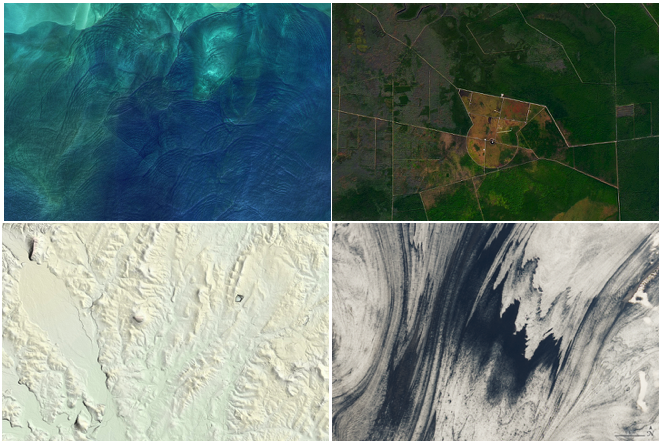
Among these, the EO Satellite Puzzler stands out for the way it engages with the readers. Since May 2011, an image has been published on the blog every month. These are satellite images of various locations on Earth, for which the blog’s readers are encouraged to guess the image’s location and significance.
Storybench spoke to Michael Carlowicz, NASA Earth Observatory’s managing editor, about the inspiration behind Earth Matters, how the images are chosen and the role of data visualization in this process.
What inspired you to start Earth Matters?
The Earth Matters blog was created as a complement to our Image of the Day (IOTD). It is an outlet for our staff to share snippets and observations that do not fit into our main line of image-driven stories. In other words, many blog items are insights and information that we want to share with our readers, but for which we cannot bring our own strong visual to the discussion.
The blog has evolved over the years to include news and outreach items from other parts of NASA: for Earth news roundups, follow-ups to our main stories, to celebrate anniversaries and mark Earth events, and for supplemental, ground-based or aerial photos to go with our satellite-driven IOTDs. Occasionally we use the blog for thematic or newsy “explainers” about a facet of Earth science for which we have special insight or for which we think our readers ought to have more context.
One permutation of Earth Matters is the monthly puzzler. One of the things we love about this job is learning what the planet looks like; you definitely want us on your trivia team for the geography questions. The puzzler is a way to engage our audience, to test their knowledge and awareness of the planet, and to have a bit of fun through a satellite brain-teaser. It can be interesting to see what answers they come up with. There are a lot of folks with really sharp eyes for the shapes and contours of this planet.
The Earth Matters blog is not a primary mission or concern of the site. It is a complementary piece of what we do, an outlet for interesting things that we learn but which do not fit properly into other bins on our site.
What is the process for choosing images each month?
The writers and visualizers on our team constantly find and discover remote and obscure places — views of Earth that are new to our staff. Choosing the puzzler is usually as simple as looking at the cool imagery that comes across our desks and thinking: “Will people easily recognize that?” We tend to pick a puzzler based on our own fascination with the beauty of a place and our curiosity to answer: “What is that?”
Occasionally, we have to skip a potential puzzler because it is too obscure; that is, we cannot find scientists, science papers, or resources to help us say anything thoughtful about the place. We are not in the business of speculating or being poetic just for the sake of it. People expect more of us at NASA Earth Observatory, and if we cannot say something meaningful and true, we don’t say it.
What role do data visualizers play?
The puzzler is always a satellite image — and almost always natural color — so the data visualizers work to process, crop, and color-correct the image. They will usually find and zoom to a detail that is compelling but does not necessarily give away the location easily. We do not use the puzzler for sharing true data visualization. That is reserved for our Images of the Day and our feature articles.
Beyond the puzzler, the Earth Matters blog is generally written by the EO writers and not the visualizers. They could write, but it has not been something they have desired to pursue. One of our previous visualizers had a passion for trading ideas with colleagues through a blog called Elegant Figures.
Earth Matters has been running since May 2011. Do you think the entire Earth will be covered anytime soon?
Not even close. [The] Earth Observatory as a whole has published more than 16,000 images in 21 years and we are not even close to showing every part of [the] planet. In fact, in the next few months, we intend to launch a map of all of the images in our archives. That will help us discover some of the holes in our coverage.
Some parts of the Earth will always be very difficult to show because cloud cover is persistent. Earth science satellites are not point-and-shoot cameras, so it is not as simple as just saying “hey, give us a shot of this place today.”
What has been the quickest reader response so far, and for which image?
Honestly, we have been doing this long enough that I cannot remember them all — and it is not data that we keep.
I do know that at least one puzzler in the early years was answered within 10 minutes. I have joked several times that there must be a fair-number of bored remote sensing specialists out there. Ha! But seriously, there are some very sharp people who either/both know the planet very well or know how to use computing tools to figure it out. For that reason, we now ask the professionals to wait a few hours or a day before they answer in order to let the amateurs have some fun with it.
Image credit: Earth Matters